- Home
- About Us
- Background
- Mandate
- Cubango Okavango River Basin
- Governance
- Strategy and Approach
- Member States
- Our Work
- Partners
- Climate Resilient Infrastructure Development Facility (CRIDF)
- European Union (EU)
- Southern African Development Community (SADC)
- Swedish International Development Cooperation Agency (SIDA)
- The World Bank (WB)
- United Nations Development Programme (UNDP)
- United States Agency For International Development (USAID)
- Resources
- News and Events
- Opportunities
- Contact Us
- FAQ's
- Connect With Us
- i
- t
- f
OKACOM Decision Support System (DSS)
In order to enable countries to make informed decisions the OKACOM Basin Development Management Framework (BDMF) identified the need for the development of basin-wide information sharing tools and a jointly agreed Decision Support Framework and Decision Support System (DSS). In order to achieve this, an operational DSS is being designed and developed, and it will serve as a vital instrument for the responsible and informed management of water and land resources of the Cubango-Okavango River Basin (CORB). The DSS will support OKACOM in its mandate to provide technical advice that aligns development and land use planning in the Member States with the CORB Vision. Another facet of the BDMF is the harmonisation of national information and data, integration of selected data into the DSS and development of basin-wide information sharing mechanisms.
The TDA, other programmes and projects leading up to the development of the OKACOM Strategic Action Plan (SAP) further commenced the development of various water resources assessment tools and models. While several such assessment tools and models have been developed to support management of the Basin resources, many are not readily available for use by the Member States and OKASEC. In addition, there are vast quantities of hydrological monitoring data and spatial data that have been collated and generated throughout the existence of OKACOM, however it remains unavailable for use in support of decision making in the basin. Henceforth, some of these assessment tools, models and data is intended to be included in the DSS that is being designed and developed with funding from the European Union Technical Support to the Programme for Transboundary Water Resources Management in the Cubango-Okavango River Basin. The project will also support the OKACOM by procuring the requisite monitoring equipment and installations to enhance the capacity of the Commission to adequately undertake monitoring and management activities in the long-term and strengthen the decision making capacity of the Commission.
Assessment tools and components of the DSS
- The DSS is intended to be comprised of a scenario assessment module, visualisation module, flood early warning system (FEWS) module and data management module.
- The scenario assessment module would largely consist of an environmental flow assessment model that would embed and link to a suite of new and existing information, including hydrological, meteorological, water quality, ecological, economic and social.
- The visualisation module will comprise of dashboards as well as GIS and remote sensing data with spatial data visualisation functions.
- The Flood Early Warning System module focus is on specific flood-prone areas in the basin
- The data management module focus is on management tools and raw data as it pertains to the OKACOM Data Sharing Procedures.
The updating and enhancing of the existing module contents, and linkage to other tools that are being developed as part of the OKACOM DSS will facilitate their utility within Member States and OKASEC.
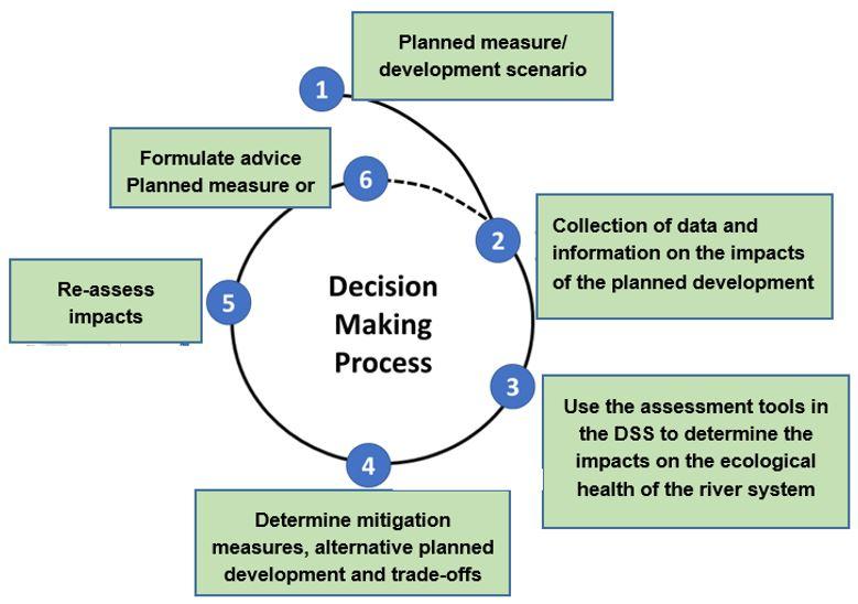
The decision support process: link between the DSS and the process of formulating technical advice on planned measures. The delivery of an operational DSS will enhance the position of OKACOM as the Technical Advisory Body for the sustainable development of the Cubango-Okavango River Basin. When any planned measures that requires prior notification based on the OKACOM Notification and Prior Consultation (NPC) guidelines, the DSS can be used to provide insight and a quick review of the impacts on the ecological and flow integrity of the river system based on available knowledge and data.
This information can then be used to guide decisions within Member States and OKACOM on the potential suitability of such planned measures/development, may highlight some of trade-offs and alternative measures, and enable future monitoring and evaluation of changes in the baseline contained in the DSS.
subscribe for news notification by email
Photo Credit: Kostatin Luchansky, National Geographic, Okavango Wilderness Project.