- Home
- About Us
- Background
- Mandate
- Cubango Okavango River Basin
- Governance
- Strategy and Approach
- Member States
- Our Work
- Partners
- Climate Resilient Infrastructure Development Facility (CRIDF)
- European Union (EU)
- Southern African Development Community (SADC)
- Swedish International Development Cooperation Agency (SIDA)
- The World Bank (WB)
- United Nations Development Programme (UNDP)
- United States Agency For International Development (USAID)
- Resources
- News and Events
- Opportunities
- Contact Us
- FAQ's
- Connect With Us
- i
- t
- f
Republic of Angola
The Republic of Angola covers 1,247,000 km² in the western region of Southern Africa. It is the second largest country in the south of the Sahara after the Democratic Republic of Congo. Area of land in the Cubango-Okavango River basin 156 250 km2. The country contains six major geomorphologic areas: Coastal area, marginal mountain chains, the old tableland, Zaire basin and the basins of the Zambezi and Cubango. Angola has two seasons, the rainy and dry (cacimbo) seasons, with an average annual rainfall of 400 mm and lowest and highest average temperatures at 18˚C and 35 ˚C respectively. The country's colonial history is reflected in its Portuguese-influenced cuisine and its landmarks including Fortaleza de São Miguel, a fortress built by the Portuguese in 1576 to defend the capital, Luanda. Angola’s HDI value for 2018 is 0.574 — which put the country in the medium human development category — positioning it at 149 out of 189 countries and territories (UN HDR 2019).
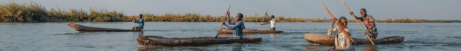
The Cubango-Okavango River rises in the headwaters of the Cuito and Cubango-Okavango Rivers in the highland plateau of Angola. The topographic extent of the Cubango-Okavango Basin comprises approximately 700,000 square km but derives its principal flow from 120,000 square km of sub-humid and semi-arid rangeland in the Cuando Cubango Province of Angola. Flowing from the Angolan highlands, the Cuito and Cubango Rivers meet to form the Cubango-Okavango along the border of Namibia and Angola before flowing through the panhandle and spilling into the Okavango Delta or fan in Botswana.
| Key indicators and Data |
|---|
|
Capital city Luanda |
|
Population (2018 est.) 30 809 762 |
|
Population density (estimated average) 26/km2 |
|
Population in the Cubango-Okavango basin (2011 est.) 571 572 |
|
Area of land in the Cubango-Okavango River basin 156 250 km2 |
|
Human Development Index (2018) 0,574 |
|
149th out of 189 countries and territories |
|
GDP (2017 est.) US$ 124.2 billion (total) |
|
US$ 4 170 (PPP-per capita) |
|
Economic Growth Rate (est. 2019) 1,2 % |
|
Neighbouring countries Democratic Republic of the Congo, Republic of Zambia, Republic of Namibia |
subscribe for news notification by email
Photo Credit: Kostatin Luchansky, National Geographic, Okavango Wilderness Project.